Due to the recent changes by the Trump administration regarding the collection of duties for small packages, we currently no longer ship to the United States. If you have shipping questions, please call 250-877-7744
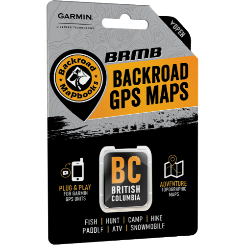
Backroads MapBooks British Columbia Garmin-Compatible GPS Maps (SD Card)
$150.00
Comprehensive and detailed maps for your Garmin® GPS. This microSD card is packed with details and covers cities and parks across Vancouver Island, Vancouver Coast & Mountains, Thompson Okanagan, Kootenay Rockies, Cariboo Chilcotin Coast, and Northern BC regions
In stock: 3 available
1
Product Details
UPC: 622098002164
Brand: Backroad Map Books
Where the Sea Meets the Sky
From the islands of Haida Gwaii, where the wilderness rules and a strong First Nations culture maintains an unbreakable bond with nature, to the rugged peaks of the Rocky Mountains, world-famous for their alpine majesty, BC is a land of extreme beauty. In the western part of the province, the Coast Mountains rise right out of the ocean, their slopes covered in lush temperate rainforest, while moving inland brings you to the sweeping Chilcotin steppe, giving way to the vast and powerful backcountry of the north. To the south, the Okanagan is known for its many beaches, lakes and desert-like landscape, while further east the Kootenays are home to one of the world’s richest and most vibrant mountain cultures. No matter which corner of the province you are exploring, BC is as exciting a destination as you can find anywhere in the world.
British Columbia Backroad GPS at a Glance:
- Combining city and backcountry navigation with enhanced outdoor recreation information, this product amalgamates all of BC into one Backroad GPS Map, including our Vancouver Island, Vancouver, Coast and Mountains, Cariboo Chilcotin Coast, Northern BC, Okanagan and Kootenay Rockies Backroad Mapbook titles.
- Close to 685,000 km of our backroads network combined into one map, including close to 200,000 km of routable roads, including close to 23,000 km of newly enhanced and named Forest Service Roads in Version 2019.
- Lake Bathymetry depth contour for 1,800+ fishing lakes, rivers, and streams in BC
- Clearly marked private leased land for anglers and hunters.
- Searchable Oil and Gas LSD Grid Locations, Compressor Stations, Gas Plants, Wellsites and other resource facilities.
- Marked Wildlife Management Units (WMUs) for hunters.
- Tens of thousands of kilometres of multi-use hiking, biking and cross-country skiing trails and paddling routes, with marked trailheads and access points/portages, including 1,500+ km of added multi-use trails and close to 400 km of new paddling routes in Version 2019.
- Over 4,400 km of new ATV and snowmobile routes in Version 2019.
- Tens of thousands of fishing hotspots, parks and conservation areas, campsites, hunting areas, winter recreation areas and more.
- Over 31,000 land and water geographic features.
- Thousands of railway corridor mile markers.
- Improved First Nations reservation coverage.
- Updated snowmobile route line style for easier navigation.
So Much More Than Just Maps!
Backroad Mapbooks’ industry-leading, Garmin-licensed British Columbia GPS Maps are the most detailed, comprehensive and up-to-date GPS maps available on the market. These are the maps of choice for recreation, industry, and search-and-rescue, with 3D views, shaded relief and countless geographic and activity based points-of-interest. Updated annually, these GPS maps are Garmin licensed for compatibility with Garmin GPS and Garmin Basecamp. Available in Micro SD format, these British Columbia GPS Maps are easy to install and use and bring you all of the detail of our wildly popular Backroad Mapbook series directly to your GPS device or computer. Keep your adventure rolling with the latest topographic data, routable roads, oil and gas data, Wildlife Management Units, trails, rec sites, paddling routes, scenic viewpoints and so much more. With the latest edition of our British Columbia GPS Maps in hand, your options for adventure are limitless.
British Columbia Backroad GPS Map Features
- Garmin-licensed & compatible with Garmin GPS™, Basecamp™, MapSource™ and RoadTrip™.
- Includes all standard Garmin features such as Find tool, city navigation and more.
- Preloaded 1:20,000 / 1:50,000 base scale seamless topographic maps.
- Provides 3D views and the highest level of map detail available on select Garmin GPS units and Basecamp™.
- Showcases private/lease land areas.
- The most complete Resource, Industry, and Logging road coverage available for British Columbia.
- Extensive routable road network including City, Resource, and Industry Roads.
- Highlights tens of thousands of kilometres of trail systems, including defined ATV, Paddling, Snowmobile, Long distance & Multi-use trails.
- Features smart background & Searchable Wildlife Management Units (WMUs).
- Includes National, Provincial, Regional, and other Parks & Campsites.
- Extras like Lake & Stream Fishing information with boat launches, paddling access points, bathymetric depths, and more.
- Searchable BRMB descriptions and activity information for fishing, paddling, parks, trails and more.
- Includes Oil and Gas LSD Grid Locations, Compressor Stations, Gas Plants, Wellsites and other Resource Facilities.
- Thousands of Searchable cities, Geographic Land, and Water features.
- Industry leading cartographic contours and shaded relief for all of British Columbia
- And much more!
Save this product for later
Backroads MapBooks British Columbia Garmin-Compatible GPS Maps (SD Card)
Display prices in:CAD

